Sunday, April 30, 2006

Manatee (Trichechus manatus latirostris)

Title: Manatee with calf, Alternative Title: (none), Creator: Rathburn, Gaylen, Source: WO3544-Highlights, Publisher: U.S. Fish and Wildlife Service, Contributor: DIVISION OF PUBLIC AFFAIRS,
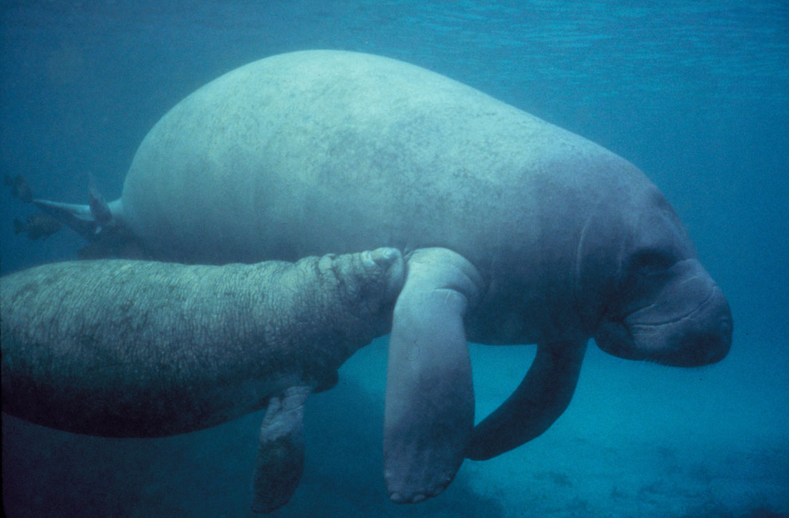
Title: Manatee calf nursing, Alternative Title: (none), Creator: Rathburn, Gaylen, Source: WO3544-Highlights, Publisher: U.S. Fish and Wildlife Service, Contributor: DIVISION OF PUBLIC AFFAIRS.
Language: EN - ENGLISH, Rights: (public domain), Audience: (general), Subject: marine mammals, wildlife, endangered.

File size: 134 KB, Format: JPEG image (image/jpeg), Dimensions: Screen: 1143px x 750px, Print: 7.62 x 5.00 inches, Resolution: 150 dpi (mid, presentation quality). Depth: Full Color.

Unless otherwise indicated, resources in the Digital Library System are in the public domain. No restrictions or copyrights are placed upon these materials. You may credit the source of the resource using the information contained in the "Creator" or "Rights" field of the resource record. Download Full High Resolution Image

File size: 1.32 MB, Format: JPEG image (image/jpeg), Dimensions: Screen: 3658px x 2400px, Print: 12.19 x 8.00 inches, Resolution: 300 dpi (high, print quality), Depth: Full Color.

Generally speaking, works created by U.S. Government employees are not eligible for copyright protection in the United States. See Circular 1 "COPYRIGHT BASICS" from the U.S. Copyright Office.

Anyone incorporating a work of the U.S. Government into a copyrighted work should be aware of 17 U.S.C. § 403. This section requires a copyright notice to contain a statement identifying what portions of the work consist of a work of the U.S.Government.

The Florida manatee, a subspecies of the West Indian manatee, occurs only in the southeastern United States. It occupies the northern limit of the species’ range, which extends south along the eastern coast of the Americas to Brazil. Manatees are slow-moving aquatic herbivores that feed in freshwater systems and the ocean. They rarely venture into near-shore ocean waters except to travel between adjacent rivers or estuaries. Prolonged exposure to water temperatures below 18°C (65°F) can be lethal to manatees. Marine Mammal Commission: Species List,

The average Florida manatee is about 10 feet long and weighs close to 1,200 pounds. Manatees can reach up to 13 feet in length and weigh 3,500 pounds. Female manatees tend to be larger than the males. Their calves weigh around 66 pounds and are 4 feet long. Fish and Wildlife Research Institute,

Leave a comment, make a request, Let this small sampling be a guide to better quality, more plentiful, public domain, royalty free, copyright free, high resolution, images, stock photos, jpeg, jpg, free for commercial use, clip art, clipart, clip-art. more at and or and or

Saturday, April 29, 2006

Leopard (Panthera pardus)

Title: Leopard, Alternative Title: (Panthera pardus), Creator: Stolz, Gary M. Source: WO5666-007, Publisher: U.S. Fish and Wildlife Service, Contributor: DIVISION OF PUBLIC AFFAIRS.Title: Leopard, Alternative Title: (Panthera pardus), Creator: Stolz, Gary M. Source: WO5666-007, Publisher: U.S. Fish and Wildlife Service, Contributor: DIVISION OF PUBLIC AFFAIRS.
Language: EN - ENGLISH, Rights: (public domain), Audience: (general), Subject: Africa, Animals, Mammals, Tanzania, Wildlife, cats, predator.

File size: 198 KB, Format: JPEG image (image/jpeg), Dimensions: Screen: 1083px x 735px, Print: 7.22 x 4.90 inches, Resolution: 150 dpi (mid, presentation quality), Depth: Full Color.

Unless otherwise indicated, resources in the Digital Library System are in the public domain. No restrictions or copyrights are placed upon these materials. You may credit the source of the resource using the information contained in the "Creator" or "Rights" field of the resource record. Download Full High Resolution Image

Generally speaking, works created by U.S. Government employees are not eligible for copyright protection in the United States. See Circular 1 "COPYRIGHT BASICS" from the U.S. Copyright Office.

Anyone incorporating a work of the U.S. Government into a copyrighted work should be aware of 17 U.S.C. § 403. This section requires a copyright notice to contain a statement identifying what portions of the work consist of a work of the U.S.Government.

The most secretive and elusive of the large carnivores, the leopard is also the shrewdest. Pound for pound, it is the strongest climber of the large cats and capable of killing prey larger than itself. African Wildlife Foundation: Wildlives

Leave a comment, make a request, Let this small sampling be a guide to better quality, more plentiful, public domain, royalty free, copyright free, high resolution, images, stock photos, jpeg, jpg, free for commercial use, clip art, clipart, clip-art. more at and or and or

Friday, April 28, 2006

Weather, Caves

W. E. Davies and I. M. Morgan  US Geological SurveyA cave is a natural opening in the ground extending beyond the zone of light and large enough to permit the entry of man. Occurring in a wide variety of rock types and caused by widely differing geological processes,
caves range in size from single small rooms to interconnecting passages many miles long. The scientific study of caves is called speleology (from the Greek words spelaion for cave and logos for study). It is a composite science based on geology, hydrology, biology, and archaeology.
Source: USGS NPS DOI Geology of Caves
USGS - U.S. Geological Survey, USGS Mapping DivisionThe Learning Web, a portion of the USGS website, is dedicated to K-12 education and life-long learning. Explore things on, in, around and about the Earth such as land, water, plants and animals, and maps. USGS Where Are America's Caves
Most U.S. Geological Survey (USGS) information resides in the public domain and may be used without restriction. There is no legal requirement for users to acknowledge or credit USGS as the source for public domain information, but they may wish to do so as a courtesy. If you wish to acknowledge or credit USGS as an information source of data or products, use a line of text as shown in the guidance below.

Credit: U.S. Geological Survey, or Department of the Interior/USGS. For images, U.S. Geological Survey/photo by Jane Doe (if the photographer/artist is known)
Recharging the ecosystem.  Sunlight shines into this cave entrance allowing abundant localized growth, which in turn provides food sources for life deeper within the cave. The National Park Service Cave and Karst ProgramRecharging the ecosystem. Sunlight shines into this cave entrance allowing abundant localized growth, which in turn provides food sources for life deeper within the cave. Karst is a region of irregular topography with sinks, underground streams, and caves that were formed by dissolution of soluble rock.
National Park Service DOI Cave and Karst Program
The National Park Service Cave and Karst Program. Information presented on this website, unless otherwise indicated , is considered in the public domain. It may may be distributed or copied as is permitted by the law.
Centuries of calcite deposition may cause stalactites and stalagmites to grow together, forming huge columns. (Ogle Cave, New Mexico JIM GOODBAR, BLMIn karst areas, rivers often disappear underground, where they continue to erode and shape the landscape. JIM GOODBAR, BLMFirst discovered in the mid-1950s, Musk Ox Cave on BLM lands in New Mexico was still being surveyed and mapped several decades later. Cave explorers have found fascinating formations as well as numerous fossil vertebrates dating from the Late Pleistocene, some 1.5 million years ago. JIM GOODBAR, BLM
This page was created by the U.S. Bureau of Land Management, Office of Public Affairs. Information presented on this website is public information and may be distributed or copied. Use of appropriate byline/photo/image credit is requested. Bureau of Land Management Welcome to the Underground
Cowboy Caves, located on the Colorado Plateau in Utah, are named for the cowboy graffiti and cattle brands scratched on the walls in relatively recent times. But they have provided archaeologists with a wealth of information about prehistoric life in the region as well. The caves show signs of human occupation beginning about 6,300 years ago, including fire pits, milling stones, grass matting, rock art, and unusual split-twig figurines. BLMCowboy Caves, located on the Colorado Plateau in Utah, are named for the cowboy graffiti and cattle brands scratched on the walls in relatively recent times. But they have provided archaeologists with a wealth of information about prehistoric life in the region as well.
The caves show signs of human occupation beginning about 6,300 years ago, including fire pits, milling stones, grass matting, rock art, and unusual split-twig figurines. BLM.

This page was created by the U.S. Bureau of Land Management, Office of Public Affairs. Information presented on this website is public information and may be distributed or copied. Use of appropriate byline/photo/image credit is requested. Cave Ecosystems Bureau of Land Management

Generally speaking, works created by U.S. Government employees are not eligible for copyright protection in the United States. See Circular 1 "COPYRIGHT BASICS" from the U.S. Copyright Office.

Anyone incorporating a work of the U.S. Government into a copyrighted work should be aware of 17 U.S.C. § 403. This section requires a copyright notice to contain a statement identifying what portions of the work consist of a work of the U.S.Government.

Leave a comment, make a request, Let this small sampling be a guide to better quality, more plentiful, public domain, royalty free, copyright free, high resolution, images, stock photos, jpeg, jpg, free for commercial use, clip art, clipart, clip-art. more at and or and or and or and

Thursday, April 27, 2006

Weather, Coral Reef

CoralReef at Johnston Atoll, NOAA Ship MCARTHUR II Marine Operations Center, PacificNOAA Ship MCARTHUR II, Marine Operations Center, Pacific, Coral Reef at Johnston Atoll - High Resolution Image, The McARTHUR II was acquired from the U.S. Navy in 2002 and was converted by NOAA.
from a T-AGOS surveillance vessel to a multiple-disciplinary platform capable of a broad range of missions.NOAA Life at Sea Ship McArthurII
Elkhorn coral and a club tip finger coral in the foreground. Image ID: reef2554, The Coral Kingdom Collection Credit: Florida Keys National Marine Sanctuary,Elkhorn coral and a club tip finger coral in the foreground. Image ID: reef2554, The Coral Kingdom Collection Credit: Florida Keys National Marine Sanctuary, High Resolution Photo Available - Click Here
Publication of the National Oceanic and Atmospheric Adminstration (NOAA), NOAA Central Library, Last Updated: 07-17-2001. NOAA Photo Library
Soft coral with polyps extended. Image ID: reef2562, The Coral Kingdom Collection Photographer: Florida Keys National Marine Sanctuary Staff Credit: Florida Keys National Marine Sanctuary, Soft coral with polyps extended. Image ID: reef2562, The Coral Kingdom Collection Photographer: Florida Keys National Marine Sanctuary Staff Credit: Florida Keys National Marine Sanctuary, High Resolution Photo Available - Click Here
Publication of the National Oceanic and Atmospheric Adminstration (NOAA), NOAA Central Library, Last Updated: 07-17-2001, NOAA Photo Library
Figures 1-8, Isophyllia dipsacea. In: 'Report on the Florida Reefs', 1880, by Louis Agassiz. Memoirs of the Museum of Comparative Zoology at Harvard College, Vol. VII, No. 1. Plate VII. These plates help document the oldest studies of the Florida Reefs. Image ID: reef2507, The Coral Kingdom Collection Location: Florida Photo Date: 1851 Field StudiesFigures 1-8, Isophyllia dipsacea. In: "Report on the Florida Reefs", 1880, by Louis Agassiz. Memoirs of the Museum of Comparative Zoology at Harvard College, Vol. VII, No. 1. Plate VII. These plates help document the oldest studies of the Florida Reefs. Image ID: reef2507, The Coral Kingdom Collection Location: Florida Photo Date: 1851 Field Studies. High Resolution Photo Available - Click Here
Publication of the National Oceanic and Atmospheric Adminstration (NOAA), NOAA Central Library, Last Updated: 07-17-2001. NOAA Photo Library
Brain coral and sea fan close-up. 1987 Florida Keys National Marine Sanctuary Photo Contest entry. Image ID: reef2585, The Coral Kingdom Collection Photographer: Steven Cook Credit: Florida Keys National Marine Sanctuary.Brain coral and sea fan close-up. 1987 Florida Keys National Marine Sanctuary Photo Contest entry. Image ID: reef2585, The Coral Kingdom Collection .
Photographer: Steven Cook Credit: Florida Keys National Marine Sanctuary. High Resolution Photo Available - Click Here Publication of the National Oceanic and Atmospheric Adminstration (NOAA), NOAA Central Library. Last Updated: 07-17-2001. NOAA Photo Library

Restrictions for Using NOAA Images, Most NOAA photos and slides are in the public domain (ALL those presented here) and CANNOT be copyrighted. Credit: National Oceanic and Atmospheric Administration/Department of Commerce unless otherwise instructed to give credit to the photographer or other source.

Generally speaking, works created by U.S. Government employees are not eligible for copyright protection in the United States. See Circular 1 "COPYRIGHT BASICS" from the U.S. Copyright Office.

Anyone incorporating a work of the U.S. Government into a copyrighted work should be aware of 17 U.S.C. § 403. This section requires a copyright notice to contain a statement identifying what portions of the work consist of a work of the U.S.Government.

Leave a comment, make a request, Let this small sampling be a guide to better quality, more plentiful, public domain, royalty free, copyright free, high resolution, images, stock photos, jpeg, jpg, free for commercial use, clip art, clipart, clip-art. more at and or and or and or and

Wednesday, April 26, 2006

Kodiak Brown Bear (Ursus arctos)

Title: Kodiak Brown Bear, Alternative Title: Ursus arctos, Creator: Hollingworth, John and Karen, Source: WV10255, Publisher: U. S. Fish and Wildlife Service, Contributor: NATIONAL CONSERVATION TRAINING CENTER-PUBLICATIONS AND TRAINING MATERIALS.
Language: EN - ENGLISH, Rights: (public domain), Audience: (general), Subject: Alaska, Animals, Kodiak National Wildlife Refuge, Mammals, Wildlife.

File size: 137 KB, Format: JPEG Image (image/pjpeg), Dimensions: Screen: 1050px x 681px, Print: 7.00 x 4.54 inches, Resolution: 150 dpi (mid, presentation quality), Depth: Full Color.

Unless otherwise indicated, resources in the Digital Library System are in the public domain. No restrictions or copyrights are placed upon these materials. You may credit the source of the resource using the information contained in the "Creator" or "Rights" field of the resource record. Download Full High Resolution Image

Generally speaking, works created by U.S. Government employees are not eligible for copyright protection in the United States. See Circular 1 "COPYRIGHT BASICS" from the U.S. Copyright Office.

Anyone incorporating a work of the U.S. Government into a copyrighted work should be aware of 17 U.S.C. § 403. This section requires a copyright notice to contain a statement identifying what portions of the work consist of a work of the U.S.Government.

Size range for females is from 500 to 700 pounds and for males 800 to 1,400 pounds. There can be a difference of 20 to 30 percent gain in weight between when they emerge from dens in the spring and when they den up in the late fall.

The oldest recorded bear was a 35 year-old female. The initial breeding age is at approximately six years-old and they will usually have two cubs in the first litter and can have up to four in subsequent litters. The average litter size is 2.3 cubs. In general, most cubs remain with their mothers until they are 2-3 years-old.

Kodiak bears breed in spring (May to early-June) and an adult female may mate with several adult males. Cubs are born in the den the following winter ( January or February) due to delayed implantation, and each sibling cub could be from a different father.

In general, after leaving the den in the spring, bears move to lower elevations where they may feed on carrion, roots or other freshly emergent vegetation. As spring progresses, they feed in the high alpine areas below the snow-line on succulent forbs and sedges. During summer, many bears move to, and stay near, streams when salmon are available in local streams. Between July and September, bears routinely supplement their diet with berries—especially salmonberry, elderberry and crowberry. After berry availability declines in September, most bear use focuses on streams which provide late run salmon. Some bears may prey on deer, but it depends on the individual bear. SOURCE: Bear Facts Kodiak National Wildlife Refuge

Leave a comment, make a request, Let this small sampling be a guide to better quality, more plentiful, public domain, royalty free, copyright free, high resolution, images, stock photos, jpeg, jpg, free for commercial use, clip art, clipart, clip-art. more at and or and or

Tuesday, April 25, 2006

The Aurora Borealis Northern Lights


The Aurora Borealis (commonly referred to as the Northern Lights) are the result of interactions between the Sun and Earth's outer atmosphere. The Aurora Australis is the southern hemisphere counterpart to the Aurora Borealis. NOAA AURORA BOREALIS (NORTHERN LIGHTS).

An aurora (plural: aurorae or auroras; from the Latin word aurora, "sunrise" or the Roman goddess of dawn) is a natural light display in the sky particularly in the high latitude (Arctic and Antarctic) regions, caused by the collision of energetic charged particles with atoms in the high altitude atmosphere (thermosphere).

NOAA Photo Library - NOAA Photo Library - Paths Less Taken - NOAA at the Ends of the Earth.


Restrictions for Using NOAA Images, Most NOAA photos and slides are in the public domain (ALL those presented here) and CANNOT be copyrighted. Credit: National Oceanic and Atmospheric Administration/Department of Commerce unless otherwise instructed to give credit to the photographer or other source.

NOAA's National Weather Service, Sioux Falls, SD Weather Forecast Office, 26 Weather Lane, Sioux Falls, SD 57104-0198, NOAA AURORA BOREALIS (NORTHERN LIGHTS)The information on government servers are in the public domain, (This Image) unless specifically annotated otherwise, and may be used freely by the public.
Aurora borealis - the Northern Lights. Image ID: corp1914, NOAA Corps Collection Photo Date: November 1991 Photographer: Commander John Bortniak, NOAA CorpsAurora borealis - the Northern Lights. Image ID: corp1914, NOAA Corps Collection Photo Date: November 1991 Photographer: Commander John Bortniak, NOAA Corps.

AURORA BOREALIS (NORTHERN LIGHTS) Wrangell-St. Elias National Park and Preserve. National Park Service, United States Department of the Interior.AURORA BOREALIS (NORTHERN LIGHTS) Wrangell-St. Elias National Park and Preserve. National Park Service, United States Department of the Interior.


Ownership Notice, National Park Service, United States Department of the Interior. Information presented on this website, unless otherwise indicated , is considered in the public domain. It may may be distributed or copied as is permitted by the law.

A wide variety of outdoor enthusiasts come here to enjoy the scenery, float the rivers, view glaciers, climb mountains, and get out into true wilderness.

Aurora borealis, the Northern Lights, captured by an inexpensive digital camera. Image ID: noaa6536, NOAA's Online World Collection Location: Minnesota, LaPorte Photo Date: 2000 Spring Photographer: Steve 'Woodtick' Doke Credit: National Weather Service Forecast Office Duluth MN.Aurora borealis, the Northern Lights, captured by an inexpensive digital camera. Image ID: noaa6536, NOAA's Online World Collection
Location: Minnesota, LaPorte Photo Date: 2000 Spring Photographer: Steve "Woodtick" Doke Credit: National Weather Service Forecast Office Duluth MN. Link: NOAA's National Weather Service, Duluth, MN Weather Forecast Office, Publication of the National Oceanic and Atmospheric Adminstration (NOAA), NOAA Central Library, Last Updated: 07-11-2002. NOAA Photo Library/NOAA's Online World,

Generally speaking, works created by U.S. Government employees are not eligible for copyright protection in the United States. See Circular 1 "COPYRIGHT BASICS" from the U.S. Copyright Office.

Anyone incorporating a work of the U.S. Government into a copyrighted work should be aware of 17 U.S.C. § 403. This section requires a copyright notice to contain a statement identifying what portions of the work consist of a work of the U.S.Government.

Let this small sampling be a guide to better quality, more plentiful, public domain, royalty free, copyright free, high resolution, images, stock photos, jpeg, jpg, free for commercial use, clip art, clipart, clip-art. more at Public Domain Clip Art and clip art or public domain and Weather or Department of the Interior or NOAA and National Oceanic & Atmospheric Administration or National Park Servuce and AURORA BOREALIS.

Monday, April 24, 2006

Weather, Flood

National Climatic Data Center, NOAAClimate Monitoring in the 21st Century brochure: 11x17", 3-fold brochure relating to the Key Elements of Climate Monitoriing. Disaster Planning and Response, Climate Variability and Change, Climate Monitoring and Alerts, Improving Societies and Economies.
NOAA Climate Monitoring May 2003 - High Resolution Image
National Weather Service, Office of Hydrologic Development, National Oceanic and Atmospheric Administration, National Weather Service.The Hydrologic Software Engineering Branch (HSEB), prepares implementation level requirements for and implements, tests, documents, controls, and maintains applications and database software to be used by field offices to conduct the hydrologic services program.- NOAA Hydrolic Software Engineering Branch
NOAA - High Resolution Image. The information on government servers are in the public domain, unless specifically annotated otherwise, (This Image) and may be used freely by the public.
Many busineses were closed during the flood like the one depicited in this photo of a Riverboat Ride Sign under water. .S. Department of the Interior, U.S. Geological SurveyUSGS Flood 1993, Many busineses were closed during the flood like the one depicited in this photo of a Riverboat Ride Sign under water. High Resolution Image
Information presented on this website (U.S. Geological Survey) is considered public information (unless otherwise noted) and may be distributed or copied. Use of appropriate byline/photo/image credit is requested.

August 1, 1993, the largest peak discharge since 1844 was measured at St. Louis on the Mississippi River by the U.S. Geological Survey.
USGS Flood 1993

The Great Flood of 1993. The Great Flood of 1993 constituted the most costly and devastating flood to ravage the United States in modern history.
USGS Flood 1993

Restrictions for Using NOAA Images, Most NOAA photos and slides are in the public domain (ALL those presented here) and CANNOT be copyrighted. Credit: National Oceanic and Atmospheric Administration/Department of Commerce unless otherwise instructed to give credit to the photographer or other source.

Generally speaking, works created by U.S. Government employees are not eligible for copyright protection in the United States. See
Circular 1 "COPYRIGHT BASICS" from the U.S. Copyright Office.

Anyone incorporating a work of the U.S. Government into a copyrighted work should be aware of 17 U.S.C. § 403. This section requires a copyright notice to contain a statement identifying what portions of the work consist of a work of the U.S.Government.

Leave a comment, make a request, Let this small sampling be a guide to better quality, more plentiful, public domain, royalty free, copyright free, high resolution, images, stock photos, jpeg, jpg, free for commercial use, clip art, clipart, clip-art. more at
and or and or and or and or

Sunday, April 23, 2006

Weather, Fog

The difference between fog and clouds which form above the Earth's surface is that rising air is not required to form fog. Fog develops when air having a relatively high humidity content (i.e., moist) comes in contact with a colder surface, often the Earth's surface, and cools to the dew point. Additional cooling leads to condensation and the growth of low-level clouds.

Fog that develops when warmer air moves over a colder surface is known as advective fog. Another form of fog, known as radiative fog, develops at night when surface temperatures cool. If the air is still, the fog layer does not readily mix with the air above it, which encourages the development of shallow ground fog. Source: USGS. USGS-authored or produced data and information are considered to be in the U.S. public domain.

Early morning fog on a southern lake, Image ID: wea00153, Historic NWS Collection. NOAA.Early morning fog on a southern lake, Image ID: wea00153, Historic NWS Collection, High Resolution Photo Available - Click Here , --- NOAA Photo Library
North side of the Golden Gate Bridge disappearing into the fog, Image ID: wea00155, Historic NWS Collection. NOAA.North side of the Golden Gate Bridge disappearing into the fog, Image ID: wea00155, Historic NWS Collection, High Resolution Photo Available - Click Here , --- NOAA Photo Library
Driving in dense fog during the 2002 fog season.High Resolution Image, Driving in dense fog during the 2002 fog season. The information on government servers (This Photo) are in the public domain, unless specifically annotated otherwise, and may be used freely by the public. NOAA
Restrictions for Using NOAA Images, Most NOAA photos and slides are in the public domain (ALL those presented here) and CANNOT be copyrighted. Credit: National Oceanic and Atmospheric Administration/Department of Commerce unless otherwise instructed to give credit to the photographer or other source.

Generally speaking, works created by U.S. Government employees are not eligible for copyright protection in the United States. See Circular 1 "COPYRIGHT BASICS" from the U.S. Copyright Office.

Anyone incorporating a work of the U.S. Government into a copyrighted work should be aware of 17 U.S.C. § 403. This section requires a copyright notice to contain a statement identifying what portions of the work consist of a work of the U.S.Government.

Leave a comment, make a request, Let this small sampling be a guide to better quality, more plentiful, public domain, royalty free, copyright free, high resolution, images, stock photos, jpeg, jpg, free for commercial use, clip art, clipart, clip-art. more at and or and or and or and

Saturday, April 22, 2006

Weather Blizzard

METEOSAT colorized infrared image of the ;Storm of the Century', the Blizzard of 1993. Credit: NESDIS/National Climatic Data Center.METEOSAT colorized infrared image of the "Storm of the Century", the Blizzard of 1993. Image ID: noaa1131, NOAA's Online World Collection Location: United States, East Coast.
Photo Date: 1993 March 13 1800 UTC Credit: NESDIS/National Climatic Data Center Link: National Climatic Data Center - (NCDC) is the world's largest active archive of weather data. NCDC produces numerous climate publications and responds to data requests from all over the world. High Resolution Photo Available - Click Here . Publication of the National Oceanic and Atmospheric Adminstration (NOAA), NOAA Central Library, Last Updated: 07-11-2002. NOAA Photo Library
The Blizzard of '93 in northern Arkansas. Sure was a lot of snow for a southern state! Image ID: wea00980, Historic NWS Collection Location: Bull Shoals, Arkansas Photo Date: 1993 Photographer: Elizabeth A. Hobbs.The Blizzard of '93 in northern Arkansas. Sure was a lot of snow for a southern state! Image ID: wea00980, Historic NWS Collection Location: Bull Shoals, Arkansas Photo Date: 1993 Photographer: Elizabeth A. Hobbs. High Resolution Photo Available - Click Here , Publication of the National Oceanic & Atmospheric Adminstration (NOAA), NOAA Central Library, Last Updated: 08-31-2004. NOAA Photo Library
Young steer after a March blizzard. Blizzard conditions are extremely hard on exposed livestock. Image ID: wea00950, Historic NWS Collection Location: Rapid City, South Dakota Photo Date: March 4, 1966Young steer after a March blizzard. Blizzard conditions are extremely hard on exposed livestock. Image ID: wea00950, Historic NWS Collection Location: Rapid City, South Dakota Photo Date: March 4, 1966
High Resolution Photo Available - Click Here . Publication of the National Oceanic & Atmospheric Adminstration (NOAA), NOAA Central Library, Last Updated: 08-31-2004. NOAA Photo Library
National Weather Service Forecast Office - Albuquerque, NM, By David Thornburg.March 15, 2005. Las Vegas, NM. Digging out following a major winter storm that dumped nearly 2 feet of snow in less than 24 hours. By David Thornburg. NOAA National Weather Service Las Vegas Blizzard March 15, 2005
The information on government servers (This Photo) are in the public domain, unless specifically annotated otherwise, and may be used freely by the public.

Restrictions for Using NOAA Images, Most NOAA photos and slides are in the public domain (ALL those presented here) and CANNOT be copyrighted. Credit: National Oceanic and Atmospheric Administration/Department of Commerce unless otherwise instructed to give credit to the photographer or other source.

Generally speaking, works created by U.S. Government employees are not eligible for copyright protection in the United States. See Circular 1 "COPYRIGHT BASICS" from the U.S. Copyright Office.

Anyone incorporating a work of the U.S. Government into a copyrighted work should be aware of 17 U.S.C. § 403. This section requires a copyright notice to contain a statement identifying what portions of the work consist of a work of the U.S.Government.

Leave a comment, make a request, Let this small sampling be a guide to better quality, more plentiful, public domain, royalty free, copyright free, high resolution, images, stock photos, jpeg, jpg, free for commercial use, clip art, clipart, clip-art. more at and or and or and or and

Friday, April 21, 2006

Weather, Dust Storm

The Great Dust Storm by Woody Guthrie, A song in Dust Bowl Ballads

On the 14th day of April of 1935, There struck the worst of dust storms that ever filled the sky. You could see that dust storm comin',

the cloud looked deathlike black, And through our mighty nation, it left a dreadful track.... The Great Dust Storm by Woody Guthrie

A wall of dust approaching a Kansas town, Image ID: wea01414, Historic NWS Collection, NOAA A wall of dust approaching a Kansas town. In: "Effect of Dust Storms on Health," U. S. Public Health Service, Reprint No,. 1707 from the Public Health Reports, Vol. 50, no. 40, October 4, 1935.
Image ID: wea01414, Historic NWS Collection Location: Kansas Photo Date: 1935, High Resolution Photo Available - Click Here , Source: NOAA Photo Library
Effect of Dust Storms on Health, U. S. Public Health Service, NOAA, Image ID: wea01416, Historic NWS CollectionPhoto # 1 of sequence. Garden City at 5:15 p.m. Note street lights and compare to photo 2 to orient picture. In: "Effect of Dust Storms on Health," U. S. Public Health Service, Reprint No,. 1707 from the Public Health Reports, Vol. 50, no. 40, October 4, 1935.
Image ID: wea01416, Historic NWS Collection Location: Kansas Photo Date: 1935, High Resolution Photo Available - Click Here , Source: NOAA Photo Library
Effect of Dust Storms on Health, U. S. Public Health Service, NOAA, Image ID: wea01415, Historic NWS CollectionPhoto # 2 of sequence. Garden City approximately 15 minutes later after dust storm blotted out the sun. Street lights are on allowing orientation of picture . In: "Effect of Dust Storms on Health," U. S. Public Health Service, Reprint No,. 1707 from the Public Health Reports, Vol. 50, no. 40, October 4, 1935.
Image ID: wea01415, Historic NWS Collection Location: Kansas Photo Date: 1935, High Resolution Photo Available - Click Here Source: NOAA Photo Library
Dust storm approaching Stratford, Texas. Dust bowl surveying in Texas, Image ID: theb1365, Historic C&GS Collection, Credit: NOAA George E. Marsh Album.Dust storm approaching Stratford, Texas. Dust bowl surveying in Texas, Image ID: theb1365, Historic C&GS Collection Location: Stratford, Texas Photo Date: April 18, 1935 Credit: NOAA George E. Marsh Album
High Resolution Photo Available - Click Here , Source: NOAA Photo Library

NOAA Photo Library - Historic National Weather Service Album/Meteorological Monsters/Dust - Page 1, Meteorological Monsters ~ Dust

Restrictions for Using NOAA Images, Most NOAA photos and slides are in the public domain (ALL those presented here) and CANNOT be copyrighted. Credit: National Oceanic and Atmospheric Administration/Department of Commerce unless otherwise instructed to give credit to the photographer or other source.

Generally speaking, works created by U.S. Government employees are not eligible for copyright protection in the United States. See Circular 1 "COPYRIGHT BASICS" from the U.S. Copyright Office.

Anyone incorporating a work of the U.S. Government into a copyrighted work should be aware of 17 U.S.C. § 403. This section requires a copyright notice to contain a statement identifying what portions of the work consist of a work of the U.S.Government.

Leave a comment, make a request, Let this small sampling be a guide to better quality, more plentiful, public domain, royalty free, copyright free, high resolution, images, stock photos, jpeg, jpg, free for commercial use, clip art, clipart, clip-art. more at and or and or and or and

Thursday, April 20, 2006

Weather, Tidepool

Tidepool Seaweed, NOAA, Olympic Coast National Marine SanctuaryAlthough the Olympic Coast is legendary for its ample rainfall and dramatic winter squalls, overall the region's climate can be characterized as uniformly hospitable. Tidepool Seaweed, High Resolution Image
Tidepool Anemones, NOAA, Olympic Coast National Marine SanctuaryThe Olympic Coast National Marine Sanctuary embraces one of the last relatively undeveloped coastlines in the United States, Tidepool Anemones, High Resolution Image
Limpet and Seastar in Tidepool, NOAA, Olympic Coast National Marine SanctuaryMost intertidal plants and animals have elaborate life cycles that usually include a free-floating, planktonic phase. Limpet and Seastar in Tidepool, High Resolution Image
Source: NOAA's official website for Olympic Coast National Marine Sanctuary.
Tidepool Shore, NOAA, Monterey Bay National Marine SanctuaryTidepool Shore, Photo of tidepool sign adjacent to Pt. Pinos tidepools, High Resolution Image, Point Pinos Tidepool Taskforce Unveils NEW SIGNS to Protect Marine Life, And Announces Research Team to Study Human Impacts
Source: The Monterey Bay National Marine Sanctuary is one of 13 national marine sanctuaries administered by the Commerce Department's National Oceanic and Atmospheric Administration. The Sanctuary extends from Marin County to San Luis Obispo County, encompassing 300 miles of shoreline and 5,322 square miles of ocean. It is home to numerous mammals, seabirds, fish, invertebrates, and plants, in a remarkably productive coastal environment NOAA Monterey Bay National Marine Sanctuary

PACIFIC GROVE, CA: The Mayor of Pacific Grove, Sandy Koffman, along with members of the Point Pinos Tidepool Task Force, and members of the public officially unveiled six new interpretive signs at Point Pinos today.About Monterey Bay National Marine Sanctuary

Restrictions for Using NOAA Images, Most NOAA photos and slides are in the public domain (ALL those presented here) and CANNOT be copyrighted. Credit: National Oceanic and Atmospheric Administration/Department of Commerce unless otherwise instructed to give credit to the photographer or other source.

Generally speaking, works created by U.S. Government employees are not eligible for copyright protection in the United States. See Circular 1 "COPYRIGHT BASICS" from the U.S. Copyright Office.

Anyone incorporating a work of the U.S. Government into a copyrighted work should be aware of 17 U.S.C. § 403. This section requires a copyright notice to contain a statement identifying what portions of the work consist of a work of the U.S.Government.

Leave a comment, make a request, Let this small sampling be a guide to better quality, more plentiful, public domain, royalty free, copyright free, high resolution, images, stock photos, jpeg, jpg, free for commercial use, clip art, clipart, clip-art. more at and or and or and or and

Wednesday, April 19, 2006

Weather, Hurricane

Hurricane Floyd Satellite Image, Photo courtesy of NOAA/NCEPHurricane Floyd Satellite Image, Photo courtesy of NOAA NCEP, An Interactive Course on Hurricane Science and for Kids and Their Families, Protect yourself, family, pets and property before a hurricane strikes: NOAA Hurricane Awareness
The National Climatic Data Center: Hurricane Fran - Satellite Image(NCDC) is the world's largest active archive of weather data. NCDC produces numerous climate publications and responds to data requests from all over the world. The National Climatic Data Center: Hurricane Fran - Satellite Image - NOAA Hurricane Fran September 3, 1996
Hurricane Fran September 3, 1996, High Resolution Image

Hurricane: The term hurricane has it's origin in the indigenous religions of old civilizations. The Mayan storm god was named Hunraken. A god considered evil by the Taino people of the Caribbean was called Huracan.

Hurricane: A type of tropical cyclone---an organized rotating weather system that develops in the tropics. Hurricanes rotate counterclockwise in the northern hemisphere. Source NOAA pdf format
Hurricane waves striking sea wall, Image ID: wea00415, Historic NWS Collection.Hurricane waves striking sea wall, Image ID: wea00415, Historic NWS Collection. High Resolution Photo Available - Click Here, >NOAA Photo Library - Historic National Weather Service Album, NOAA
Sixteen feet of storm surge struck the Florida Panhandle during Hurricane Eloise, Image ID: wea00416, Historic NWS CollectionLocation: Florida PanhandlePhoto Date: September 23, 1975.High Resolution Photo Available - Click Here
A hurricane is a severe tropical storm that forms in the North Atlantic Ocean, the Northeast Pacific Ocean east of the dateline, or the South Pacific Ocean east of 160E. NOAA Hurricanes

Restrictions for Using NOAA Images, Most NOAA photos and slides are in the public domain (ALL those presented here) and CANNOT be copyrighted. Credit: National Oceanic and Atmospheric Administration/Department of Commerce unless otherwise instructed to give credit to the photographer or other source.

Generally speaking, works created by U.S. Government employees are not eligible for copyright protection in the United States. See Circular 1 "COPYRIGHT BASICS" from the U.S. Copyright Office.

Anyone incorporating a work of the U.S. Government into a copyrighted work should be aware of 17 U.S.C. § 403. This section requires a copyright notice to contain a statement identifying what portions of the work consist of a work of the U.S.Government.

Leave a comment, make a request, Let this small sampling be a guide to better quality, more plentiful, public domain, royalty free, copyright free, high resolution, images, stock photos, jpeg, jpg, free for commercial use, clip art, clipart, clip-art. more at and or and or and or and

Tuesday, April 18, 2006

Indian Rhinos (Rhinoceros unicornis)

Title: Indian Rhinos, Alternative Title: (Rhinoceros unicornis), Creator: Stolz, Gary M. Source: WO8458-002, Publisher: U.S. Fish and Wildlife Service, Contributor: DIVISION OF PUBLIC AFFAIRS.Title: Indian Rhinos, Alternative Title: (Rhinoceros unicornis), Creator: Stolz, Gary M. Source: WO8458-002, Publisher: U.S. Fish and Wildlife Service, Contributor: DIVISION OF PUBLIC AFFAIRS.
Language: EN - ENGLISH , Rights: (public domain), Audience: (general), Subject: Mammals, Animals, Wildlife.

Common Names, Asian Greater One-Horned Rhinoceros: referring to the single large horn, Indian and/or Nepalese rhinoceros: referring to the species' endemic range. International Rino Foundation

Related to tapirs, horses, and zebras, rhinocersoses are "odd-toed ungulates" (Order: Perissodactyla), rhinos are large herbivores that occur in Africa and tropical Asia. The Wild Ones Animal Index

The Indian rhino is found in northern Pakistan, India, Nepal, Bangladesh and Assam. It can grow to weigh a hefty 2,000 kg. Amazing facts about the Indian rhino

File size: 174 KB, Format: JPEG Image (image/pjpeg), Dimensions: Screen: 1050px x 699px, Print: 7.00 x 4.66 inches, Resolution: 150 dpi (mid, presentation quality), Depth: Full Color.

Unless otherwise indicated, resources in the Digital Library System are in the public domain. No restrictions or copyrights are placed upon these materials. You may credit the source of the resource using the information contained in the "Creator" or "Rights" field of the resource record. Download Full High Resolution Image

Generally speaking, works created by U.S. Government employees are not eligible for copyright protection in the United States. See Circular 1 "COPYRIGHT BASICS" from the U.S. Copyright Office.

Anyone incorporating a work of the U.S. Government into a copyrighted work should be aware of 17 U.S.C. § 403. This section requires a copyright notice to contain a statement identifying what portions of the work consist of a work of the U.S.Government.

Leave a comment, make a request, Let this small sampling be a guide to better quality, more plentiful, public domain, royalty free, copyright free, high resolution, images, stock photos, jpeg, jpg, free for commercial use, clip art, clipart, clip-art. more at and or and or

Sunday, April 16, 2006

Weather, Icebergs

Huge tabular icebergs, calved from the ice shelf in the Southern Ocean's Weddell Sea. (Photo courtesy of Mike Vecchione.)Huge tabular icebergs, calved from the ice shelf in the Southern Ocean's Weddell Sea. (Photo courtesy of Mike Vecchione, NOAA National Marine Fisheries Service),
Download high resolution image (jpg, 1.1 Mb) Related Links:

NOAA Ocean Explorer: Arctic Exploration - August 15 - September 8, 2002. This summer, an international team of 50 scientists from the United States, Canada, China and Japan, participated in a collaborative effort to explore the frigid depths of the Canada Basin, located in the Arctic Ocean.

NOAA Ocean Explorer: Arctic Exploration: September 6 Log - Mike Vecchione, NMFS Systematics Laboratory, National Museum of Natural History, Washington, DC. Until now, my polar experience has been in the Antarctic, where I have participated in three research cruises.

NOAA Ocean Explorer Welcome - Explore the ocean realm with NOAA. This Web site chronicles the adventures and discoveries of NOAA's at-sea science and education teams.
Arches in icebergs off the Antarctic Peninsula, Image ID: corp 2085, NOAA Corps Collection Photo Date: Austral summer 1988-1989 Photographer: Commander Richard Behn, NOAA Corps.Arches in icebergs off the Antarctic Peninsula, Image ID: corp 2085, NOAA Corps Collection Photo Date: Austral summer 1988-1989 Photographer: Commander Richard Behn, NOAA Corps. Source: NOAA
High Resolution Photo Available - Click Here
Icebergs in Disco Bay . (From a photograph.), Greely, A.W. 1886. Three Years of Arctic Service. London: Richard Bentley and Son.Icebergs in Disco Bay . (From a photograph.), Greely, A.W. 1886. Three Years of Arctic Service. London: Richard Bentley and Son .NOAA The First International Polar Year 1881-1884
Download High Resolution Image
Large tabular icebergs grounded in the Ross Sea. Image ID: corp 2404, NOAA Corps CollectionPhoto Date: 1998 December Photographer: Michael Van Woert, NOAA NESDIS, ORA,Large tabular icebergs grounded in the Ross Sea. Image ID: corp 2404, NOAA Corps Collection Photo Date: 1998 December Photographer: Michael Van Woert, NOAA NESDIS, ORA, High Resolution Photo Available - Click Here
Restrictions for Using NOAA Images, Most NOAA photos and slides are in the public domain (ALL those presented here) and CANNOT be copyrighted. Credit: National Oceanic and Atmospheric Administration/Department of Commerce unless otherwise instructed to give credit to the photographer or other source.

Generally speaking, works created by U.S. Government employees are not eligible for copyright protection in the United States. See Circular 1 "COPYRIGHT BASICS" from the U.S. Copyright Office.

Anyone incorporating a work of the U.S. Government into a copyrighted work should be aware of 17 U.S.C. § 403. This section requires a copyright notice to contain a statement identifying what portions of the work consist of a work of the U.S.Government.

Works published prior to 1978 were copyright protected for a maximum of 75 years. See Circular 1 "COPYRIGHT BASICS" from the U.S. Copyright Office. Works published works before 1923 are now in the public domain.

Leave a comment, make a request, Let this small sampling be a guide to better quality, more plentiful, public domain, royalty free, copyright free, high resolution, images, stock photos, jpeg, jpg, free for commercial use, clip art, clipart, clip-art. more at and or and or and or and

Weather, Waterfall

Bureau of Reclamation U.S. Department of the Interior, Spring runoff waterfall  -  Grand Coulee Dam (spilling)Spring runoff waterfall - Grand Coulee Dam (spilling), Information presented on this website is considered public information and may be distributed or copied. Use of appropriate byline/photo/image credit is requested (Bureau of Reclamation U.S. Department of the Interior). US Department of Interior Grand Coulee
Waterfall in the Krantz Kloof Reserve, National Oceanic and Atmospheric Administration/Department of Commerce.Waterfall in the Krantz Kloof Reserve, Restrictions for Using NOAA Images, Most NOAA photos and slides are in the public domain (ALL those presented here) and CANNOT be copyrighted. Credit: National Oceanic and Atmospheric Administration/Department of Commerce unless otherwise instructed to give credit to the photographer or other source. NOAA Marine Sanctuaries
View of Waterfall at Mossy Cave, Credit: National Park Service, Bryce Canyon National Park.View of Waterfall at Mossy Cave, Because this website is sponsored and compiled by the National Park Service, every picture and line of text (unless specified otherwise) is part of the public domain and may be copied and reused legally and without limit. National Park Service Bryce Canyon Mossy Cave Waterfall
Restrictions for Using NOAA Images, Most NOAA photos and slides are in the public domain (ALL those presented here) and CANNOT be copyrighted. Credit: National Oceanic and Atmospheric Administration/Department of Commerce unless otherwise instructed to give credit to the photographer or other source. NOAA Monteray Bay National Marine Sanctuary
National Park Service Lake Clark Scrapbook - Waterfalls are an attraction for many backpackers. Tanalian Falls flows over an old volcanic flow. An aerial view of Tanalian Falls.

Generally speaking, works created by U.S. Government employees are not eligible for copyright protection in the United States. See Circular 1 "COPYRIGHT BASICS" from the U.S. Copyright Office.

Anyone incorporating a work of the U.S. Government into a copyrighted work should be aware of 17 U.S.C. § 403. This section requires a copyright notice to contain a statement identifying what portions of the work consist of a work of the U.S.Government.

Leave a comment, make a request, Let this small sampling be a guide to better quality, more plentiful, public domain, royalty free, copyright free, high resolution, images, stock photos, jpeg, jpg, free for commercial use, clip art, clipart, clip-art. more at and or and or and or and or and