Sunday, September 24, 2006
Science and Technology, Synthetic Aperture Radars
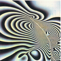
Synthetic Aperture Radars (SAR) produce all-weather, day and night, high quality pictures of the Earth's surface. By combining two or more pictures of the same area, it's possible to make maps that are highly detailed and show useful information about an area. This technique is called SAR interferometry. SAR interferometry has been applied to the study of earthquakes, volcanoes, glacier flow, landslides, and other geologic events. NASA's Role in Investigating Continental Drift
NASA images generally are not copyrighted. Unless otherwise noted, images and video on NASA public web sites (public sites ending with a nasa.gov address) may be used for any purpose without prior permission. The endorsement of any product or service by NASA must not be claimed or implied.
Generally speaking, works created by U.S. Government employees are not eligible for copyright protection in the United States. See Circular 1 "COPYRIGHT BASICS" from the U.S. Copyright Office.
Leave a comment, make a request, Let this small sampling be a guide to better quality, more plentiful, public domain, royalty free, copyright free, high resolution, images, stock photos, jpeg, jpg, free for commercial use, clip art, clipart, clip-art. more at Public Domain Clip Art and clip art or public domain and Synthetic Aperture Radars or NASA and Space Science or SAR interferometry and geologic events and Earth

No comments:
Post a Comment