


 | Target Name: Rhea, Is a satellite of: Saturn, Mission: Cassini, Spacecraft: Cassini Orbiter, Instrument: Imaging Science Subsystem - Narrow Angle, Product Size: 1124 samples x 1124 lines. |
Original Caption Released with Image:
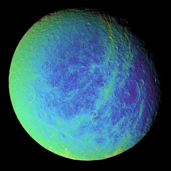
Bright, wispy markings stretch across a region of darker terrain on Saturn's moon Rhea. In this extreme false-color view, the roughly north-south fractures occur within strips of material (which appear greenish here) that are a different color from the surrounding cratered landscape.
To create the false-color view, ultraviolet, green and infrared images were combined into a single black and white picture that isolates and maps regional color differences. Most of the large-scale variations in brightness across the surface are removed by this process. This "color map" was then superimposed over a clear-filter image.
The origin of the color differences is not yet understood, but it may be caused by subtle differences in the surface composition or grain sizes making up the icy soil.
Wispy markings were seen on the trailing hemispheres of both Rhea and Dione in images taken by NASA's Voyager spacecraft, and were hypothesized by some researchers to be the result of material extruded onto the surface by ice volcanism. Cassini's earlier revelation of the braided fractures on Dione led to speculation that Rhea's wisps might also be created by fractures.
This view shows terrain on the trailing hemisphere of Rhea (1,528 kilometers, or 949 miles across). North is up.
The image was taken using the Cassini spacecraft narrow-angle camera on Jan. 17, 2006, at a distance of approximately 245,000 kilometers (152,000 miles) from Rhea and at a Sun-Rhea-spacecraft, or phase, angle of 30 degrees. Image scale is 1 kilometer (4,771 feet) per pixel.
The Cassini-Huygens mission is a cooperative project of NASA, the European Space Agency and the Italian Space Agency. The Jet Propulsion Laboratory, a division of the California Institute of Technology in Pasadena, manages the mission for NASA's Science Mission Directorate, Washington, D.C. The Cassini orbiter and its two onboard cameras were designed, developed and assembled at JPL. The imaging operations center is based at the Space Science Institute in Boulder, Colo.
For more information about the Cassini-Huygens mission visit saturn.jpl.nasa.gov/. The Cassini imaging team homepage is at ciclops.org. Image Credit: NASA/JPL/Space Science Institute
NASA images generally are not copyrighted. Unless otherwise noted, images and video on JPL public web sites (public sites ending with a jpl.nasa.gov address) may be used for any purpose without prior permission. The endorsement of any product or service by Caltech, JPL or NASA must not be claimed or implied.
Leave a comment, make a request, Let this small sampling be a guide to better quality, more plentiful, public domain, royalty free, copyright free, high resolution, images, stock photos, jpeg, jpg, free for commercial use, clip art, clipart, clip-art. more at Public Domain Clip Art and clip art or public domain and Space or NASA and Cassini-Huygens or Saturn and European Space Agency or Rhea


No comments:
Post a Comment