


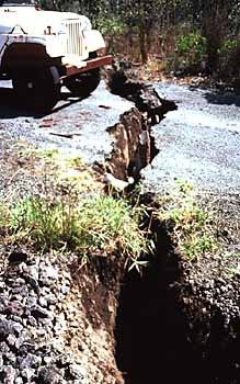
 | USGS, Damages Caused by the November 29, 1975 Earthquake, An estimated $4 million (worth approximately $13 million in 1999 dollars) of damages is attributed to the earthquake and its related catastrophic events. Photograph by Peter Lipman, US Geological Survey, Crack in Hilina Pali road, Hawaii Volcanoes National Park. High Resolution Image |
 | Photograph by Boone Morrison, Small landslide from spatter and cinder cone partially blocking, Chain of Craters Road, Hawaii Volcanoes National Park. High Resolution Image |
 | Seismograph, USGS Along with other signs of volcanic activity, we monitor earthquakes and seismic activity on Hawai`i continuously and in real-time to provide warnings of impending eruption and to assess seismic hazards in the State of Hawai`i. |
---------------Epicenter----- Maximum -----No of----
Date --------Location----- Intensity-Mag-Deaths-Damage
-------------------------------------------------------------------------------------
03 28 1868 Southern Hawaii .. IX - 7.0 0 Extensive-Southern Hawaii.
04 02 1868 Southern Hawaii .. XII -7.9 81 >100 houses destroyed, tsunami
10 05 1929 Hualalai ........... VIII 6.5 0 Extensive-Kona
08 21 1951 Kona ............... VIII 6.9 0 Extensive-Kona
04 26 1973 North of Hilo ...... VIII 6.2 0 Extensive-Hilo, $5.6M
11 29 1975 Kalapana feature . VIII 7.2 2 Extensive-Hilo, $4.1M
11 16 1983 Kaoiki .............. IX . 6.7 0 Extensive-Southern Hawaii, >$6M
06 25 1989 Kalapana .......... VII - 6.2 0 Southeast Hawaii almost $1M
-------------------------------------------------------------------------------------
* from USGS Bulletin 2006, Isoseismal Maps, Macroseismic Epicenters, and Estimated Magnitudes of Historical Earthquakes in the Hawaiian Islands by Max Wyss and Robert Koyanagi.
Large Earthquakes in the United States, Santa Cruz Mountains (Loma Prieta), California, 1989 10 18 00:04:15 UTC (Local 10/17/1989), Magnitude 6.9, Intensity IX
Damage Photos.
About the Images, The original images are either 35mm slide transparencies or digital. Unless noted on the image and caption, the photographs were taken by scientists of the U.S. Geological Survey and are in the public domain. If you use the images, please credit U.S. Department of Interior, U.S. Geological Survey.
Generally speaking, works created by U.S. Government employees are not eligible for copyright protection in the United States. See Circular 1 "COPYRIGHT BASICS" from the U.S. Copyright Office.
Anyone incorporating a work of the U.S. Government into a copyrighted work should be aware of 17 U.S.C. § 403. This section requires a copyright notice to contain a statement identifying what portions of the work consist of a work of the U.S.Government.
Leave a comment, make a request, Let this small sampling be a guide to better quality, more plentiful, public domain, royalty free, copyright free, high resolution, images, stock photos, jpeg, jpg, free for commercial use, clip art, clipart, clip-art.


No comments:
Post a Comment