


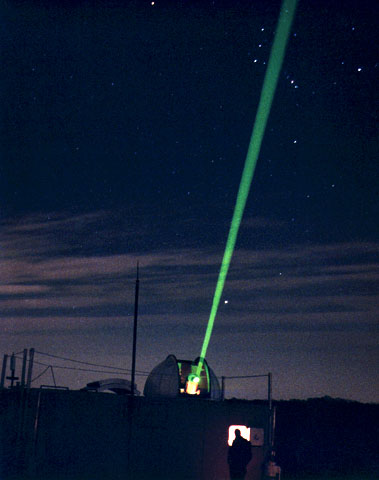
 | Satellite Laser Ranging (SLR) system operating in Greenbelt, Maryland. SLR systems are equpped with short-pulse laser transmitters that can range to orbiting satellites. Lunar Laser Ranging (LLR) systems can range to retroreflectors located on the moon. |
The service also develops the necessary standards/specifications and encourages international adherence to its conventions. The ILRS collects, merges, archives and distributes Satellite Laser Ranging (SLR) and Lunar Laser Ranging (LLR) observation datasets of sufficient accuracy to satisfy the objectives of a wide range of scientific, engineering, and operational applications and experimentation. FULL TEXT
NASA images generally are not copyrighted. Unless otherwise noted, images and video on NASA public web sites (public sites ending with a nasa.gov address) may be used for any purpose without prior permission. The endorsement of any product or service by NASA must not be claimed or implied.
Generally speaking, works created by U.S. Government employees are not eligible for copyright protection in the United States. See Circular 1 "COPYRIGHT BASICS" from the U.S. Copyright Office.
Leave a comment, make a request, Let this small sampling be a guide to better quality, more plentiful, public domain, royalty free, copyright free, high resolution, images, stock photos, jpeg, jpg, free for commercial use, clip art, clipart, clip-art. more at Public Domain Clip Art and clip art or public domain and Satellite Laser Ranging or NASA and Space Science or Moon andspacecraft and Earth


No comments:
Post a Comment